Against the backdrop of climate change, local authorities increasingly see it as their responsibility to integrate climate adaptation measures into urban development concepts and plans.
Against this background, the overarching goal of the UrbanGreenEye project is to establish satellite data as a tool for action in municipal administration and planning processes in the determination of climate adaptation-relevant parameters. The aim is to create a uniform information and decision-making basis for municipal planning instruments such as landscape plans, land use plans or development plans, as well as for the development of urban planning concepts and urban development plans.
Planned workflow in the UrbanGreenEye project
A cloud-based data portal will provide municipalities with access to important annually updated indicators for climate adaptation free of charge. This includes indices of thermal load and relief as well as hydrological relief, which are provided as a quantitative measure for integration and reuse in geographic information systems (GIS). The indices will be available nationwide for all municipalities and thus create a nationally uniform data basis for qualitative and quantitative indicators for municipal climate adaptation strategies.
The focus of thermal stress is on indices of surface temperature, shading, and albedo. The relationship between surface temperature and air temperature will be analysed using a microscale climate model (PALM-4U) and in-situ measurement data. The thermal stress indices can be used in the context of heat action plans or climate function maps.
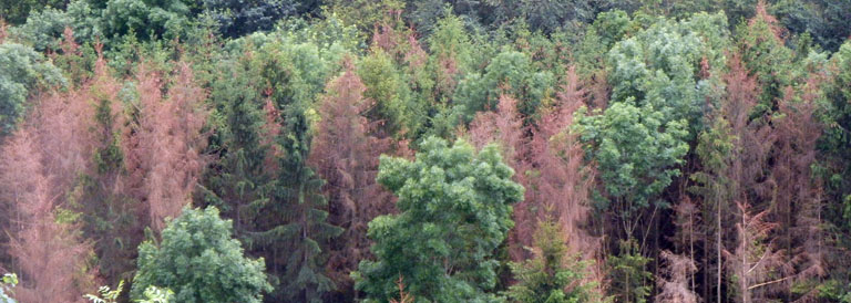
Thermal relief, on the other hand, includes quantitative parameters on green volume, equipment and quality. Green space plays a role in the consideration of green space networking and the promotion of biodiversity and the fresh air circulation. The vitality of vegetation, an aspect of green quality, depends not only on pest infestation, but also on the water availability of the soil and provides information about drought stress. On the other hand, the condition (green quality) and the amount of vegetation (green volume) determine the potential of the vegetation’s cooling capacity and, in conjunction with the cooling capacity of the soil, are taken into account in thermal relief. The focus on hydrological relief provides indices such as the proportion of sealed areas and infiltration.
The combination of the surface temperature, green volume and sealing indices for thermal ventilation and relief is intended to provide qualitative indications of urban spaces particularly affected by heat in the form of a deficit analysis and thus identify areas of deficit where countermeasures can be taken.
Using building-resolving urban climate modeling with PALM-4U, the remotely sensed data will be transferred to ground-level meteorological and bio-meteorological variables. Furthermore, the effects of uncertainties in the satellite-based calculation of the green volume will be investigated and the results of the deficit analysis will be validated and expanded. Scenario calculations will be used to show the effects of specific adaptation measures for areas with a high deficit.
By means of building-resolving urban climate modelling with PALM-4U, the remote sensing data are transferred to ground-level meteorological and bio-meteorological variables. Furthermore, the effects of uncertainties in the satellite-based calculation of the green volume will be investigated and the results of the deficit analysis will be validated and extended. Scenario calculations are intended to show the effects of specific adaptation measures for areas with a high deficit.
As a particularly important goal of the project, the possibilities of integration into municipal planning and procedures are shown by way of example with the help of municipal practice partners. The aim is to ensure that the results on climate adaptation can also be integrated into other municipal areas of action. For example, the green volume figure, similar to the biotope area factor or the number of building masses, could be considered as a quantitative measure of urban greenery as a new urban planning indicator and decision-making criterion. In the course of densification, the qualification of the existing green space should also be included. By integrating the data into geographic information systems, the data can be used, for example, to record and monitor urban green spaces or to expand green space cadastres, as well as for the block-based development of climate adaptation strategies for municipal tasks and services. The aim of the project is thus to develop a supra-regional lighthouse function.
In addition to the city of Leipzig as a project partner, the cities of Hamburg, Duisburg, Potsdam, Stuttgart and Augsburg, as well as 13 cities and municipalities in the Gütersloh district, are participating in the project as pilot partners.
Further information, updates and dates can be found on the official UrbanGreenEye website: www.urbangreeneye.de
Project start: January 2022 Duration: 36 months
Partners:
- Technische Universität Berlin (TU Berlin) – Urban Ecology Group
- City of Leipzig
FKZ: 50EW2201A
Funded within the framework of the funding guideline “Development and implementation preparation of Copernicus services for public needs on the topic of climate adaptation strategies for municipal applications in Germany” of the Federal Ministry for Digital and Transport (BMDV).